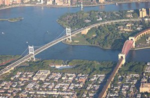
Wards Island Aerial View » Wards Island Aerial View

Looking north towards Wards Island (top) along the Triborough Bridge (left) and the Hell Gate Bridge (right). This southern tip of the island is slated for a "Renewable Energy Park"

  • Wards Island Aerial View
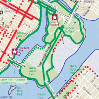
  • Wards-Randall Island Map

This entry was posted on Tuesday, October 27th, 2009 at 8:46 am and is filed under . You can follow any responses to this entry through the RSS 2.0 feed. You can leave a response, or trackback from your own site.


Join our Mailing List

Subscribe to our mailing list

* indicates required