Renewable energy site appraisal tool

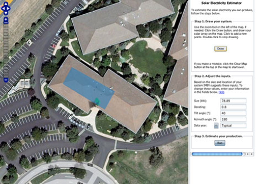
The blue rectangle, above, encloses a sample area for renewable energy production at one site, viewed using the IMBY online tool.
A new online data mapping tool called IMBY – or In My Backyard (a play on NIMBY)– allows users to estimate the potential for renewable energy production on any given site, whether it’s a backyard, a roof or an empty lot. The IMBY tool was developed by the National Renewable Energy Laboratory (NREL), the federal agency dedicated to renewable energy research, development and outreach. Using a Google Maps interface, IMBY locates a specific address and allows the user to choose either wind or solar power and then draw the perimeter for a future renewable energy site. Based on information from geostationary satellites, AWS Truewind data, and NREL renewable energy databases, IMBY provides an estimate on the given site’s production potential. For solar energy, this includes the initial cost of the system, amount of cash incentives expected and the approximate number of payback years. For wind power, IMBY estimates the local wind resource based on the time of year and provides an estimated electricity output. The tool was designed for homeowners, businesses and researchers to access quick estimates for sites in the continental United States, Hawaii and northern Mexico.
(via Treehugger)


