Manhattan, primeval
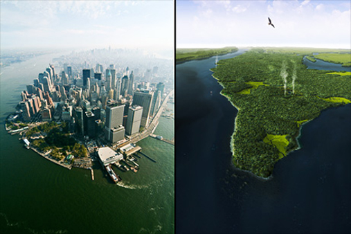
Digital re-creation by Markley Boyer
For the 400th anniversary of Henry Hudson’s arrival at Manahatta Island, the Wildlife Conservation Society and ecologist Eric W. Sanderson have prepared the Manahatta Project, a massive GIS-based portrait of the topography and ecology of Manhattan as it was in 1609. The research behind the Manahatta Project drew from historical maps, soil cores, tree rings, contemporary field work and a variety of historical accounts. The centerpiece of the now-finished decade-long project is a digital interactive map. The project has also produced lesson plans for grade school and high school students which draw on the new body of knowledge on Manhattan’s original ecology. Beyond providing a historical and educational resource, the project is intended to spur conversation about the present and future urban ecologies of New York City.
The project is being showcased at the Museum of the City of New York now through October 12.